EVLA — LIEPAJA
Note: The following sections in this chapter are intentionally left blank: AD 2.16, AD 2.21.
EVLA AD 2.1 AERODROME LOCATION INDICATOR AND NAME
EVLA — LIEPAJA
EVLA AD 2.2 AERODROME GEOGRAPHICAL AND ADMINISTRATIVE DATA
| 1 | ARP coordinates and site at AD |
563103N 0210549E 1002 m from THR 06 |
|---|---|---|
| 2 | Direction and distance of ARP from centre of the city | 90°, 2.7 NM from the centre of Liepaja |
| 3 | Elevation/Reference temperature/Mean low temperature | 18 FT / 23.2º C / -16.5º C |
| 4 | Geoid undulation at AD ELEV PSN | 78 FT |
| 5 | MAG VAR/Annual Change | 6º E (2016) / 0.13º increasing |
| 6 | AD operator, address, telephone, telefax, email, AFS, website |
AVIASABIEDRIBA LIEPAJA LTD Post:
Lidostas iela 8, Cimdenieki Phone: +371 63407592, +371 20299577 Fax: +371 63407592 Email: info@liepaja-airport.lv AFS: EVLA |
| 7 | Types of traffic permitted (IFR/VFR) | IFR/VFR |
| 8 | Remarks | NIL |
EVLA AD 2.3 OPERATIONAL HOURS
| 1 | AD |
See NOTAM or SUP. |
|---|---|---|
| AD operator |
MON-FRI 0700-1500 (0600-1400) | |
| 2 | Customs and immigration | O/R |
| 3 | Health and sanitation | O/R |
| 4 | AIS Briefing Office | Self-briefing is available H24 on https://ibs.lgs.lv. Verbal briefing is available H24 by phone +371 67300 675. |
| 5 | ATS Reporting Office (ARO) | ARO Riga H24 Tel: +371 6 7300 642 Tel: +371 6 7783 761 (back-up phone) Self-briefing is available H24 on https://ibs.lgs.lv. |
| 6 | MET Briefing Office | Pre-flight planning room during operational hours of AFIS unit. MET information for flight documentation is available on request via ARO Riga H24: phone: +371 6 7300 642, +371 6 7300 645, +371 6 7783 761 (back-up phone). Self-briefing is available H24 on https://ibs.lgs.lv. |
| 7 | ATS | AFIS as AD (changes to OPR HR see NOTAM or SUP) |
| 8 | Fuelling | As AD |
| 9 | Handling | As AD |
| 10 | Security | As AD |
| 11 | De-icing | As AD (on prior request) |
| 12 | Remarks | For NON-SCHENGEN flights and services outside AD operational hours PPR must be submitted during AD operator operational hours at least 24 HR prior to flight by phone +371 20299577; +371 26620855; +371 26 770215; E-mail: info@liepaja-airport.lv. Service will be provided if possible and client will be notified. The number of the AD operator permission must be entered in item 18 of the ICAO flight plan (if FPL is submitted). |
EVLA AD 2.4 HANDLING SERVICES AND FACILITIES
| 1 | Cargo-handling facilities | NIL |
|---|---|---|
| 2 | Fuel/oil types | Fuel: Jet A-1* AVGAS 100LL* Oil: NIL |
| 3 | Fuelling facilities/capacity | Jet A-1: Stationary fuel station: 20 000 litres/2 litres per sec. Fuel truck: 20 000 litres/15 litres per sec. AVGAS 100LL: Available in factory sealed drums. |
| 4 | De-icing facilities | Service provided by AD. 1 truck |
| 5 | Hangar space for visiting aircraft | NIL |
| 6 | Repair facilities for visiting aircraft | NIL |
| 7 | Remarks | No dangerous cargo transportation is permitted. * Fuel available on prior request, phone: +371 20299577; +371 63407592 or e-mail: info@liepaja-airport.lv |
EVLA AD 2.5 PASSENGER FACILITIES
| 1 | Hotels | In the city |
|---|---|---|
| 2 | Restaurants | In the city |
| 3 | Transportation | Bus, taxi |
| 4 | Medical facilities | First aid at AD, hospitals in the city |
| 5 | Bank and Post Office | In the city |
| 6 | Tourist Office | Tourist information available at the Information desk |
| 7 | Remarks | NIL |
EVLA AD 2.6 RESCUE AND FIRE FIGHTING SERVICES
| 1 | AD category for fire fighting | A2 A7 For scheduled flights up to CAT A7. For other flights up to CAT A7 O/R by prior arrangement at least 48 HR before ETA via e-mail: info@liepaja-airport.lv. |
|---|---|---|
| 2 | Rescue equipment | 2 fire fighting trucks, 1 motorboat |
| 3 | Capability for removal of disabled aircraft | Not AVBL |
| 4 | Remarks | The registered owner or aircraft operator retains complete responsibility for the removal of the disabled aircraft. All airline operators at EVLA are expected to have aircraft recovery plans. |
EVLA AD 2.7 SEASONAL AVAILABILITY - CLEARING
| 1 | Types of clearing equipment | 2 snow ploughs, 2 snow brushes, 1 snow blower, 1 dry chemical spreader, 1 sand spreader |
|---|---|---|
| 2 | Clearance priorities | 1. RWY; 2. TWY; 3. Apron |
| 3 | Remarks | Information on snow clearance published from OCT - APR in NOTAM (SNOWTAM). See also the Snow Plan section AD 1.2.2. |
EVLA AD 2.8 APRONS, TAXIWAYS AND CHECK LOCATIONS/POSITIONS DATA
| 1 | Apron designation, surface and strength | APRON Surface: ASPH Strength: PCN 36/F/C/X/T STAND 1 Surface: ASPH Strength: PCN 48/F/D/X/T STAND 2 Surface: ASPH Strength: PCN 46/F/C/X/T STAND 3 Surface: CONC Strength: PCN 60/R/B/X/T |
|---|---|---|
| 2 | Taxiway designation, width, surface and strength | TWY B Width: 18M Surface: ASPH Strength: PCN 73/F/A/X/T |
| 3 | Altimeter checkpoint location and elevation | At Apron, 11 FT |
| 4 | Location of VOR checkpoints | NIL |
| 5 | Position of INS checkpoints | NIL |
| 6 | Remarks | NIL |
EVLA AD 2.9 SURFACE MOVEMENT GUIDANCE AND CONTROL SYSTEM AND MARKINGS
| 1 | Use of aircraft stand ID signs, TWY guide lines and visual docking/parking guidance system at aircraft stands | Sign boards at all intersections with TWY and RWY and at all holding PSN. Guide lines at APRON. |
|---|---|---|
| 2 | RWY and TWY markings and LGT | RWY: Designation of THR, TDZ, CL, RWY edge marked. TWY: Holding PSN, CL marked. |
| 3 | Stop bars and RWY guard lights | NIL |
| 4 | Other RWY protection measures | NIL |
| 5 | Remarks | NIL |
EVLA AD 2.10 AERODROME OBSTACLES
Information on Obstacle Data Set availability and access rights is provided in GEN 3.1.6. Last update: 20 May 2021.
EVLA AD 2.11 METEOROLOGICAL INFORMATION PROVIDED
|
1 |
Associated MET Office |
Riga |
|
2 |
Hours of service MET Office outside hours |
H24 - |
|
3 |
Office responsible for TAF preparation |
Riga |
|
Periods of validity |
24 HR (0024; 0303; 0606; 0909; 1212;1515;1818; 2121) | |
|
Interval of issuance |
3 HR | |
|
4 |
Trend forecast Interval of issuance |
NIL |
|
5 |
Briefing/consultation provided |
Flight documentation is provided O/R by ARO Riga H24, phone: +371 67300642, +371 67300645, +371 67783761 (back-up phone). Consultation is provided O/R by MET office Riga H24, phone: +371 67142005 |
|
6 |
Flight documentation |
TAF, METAR, SIGMET, GAMET, AIRMET, WAFS charts, SWL |
|
Language(s) used |
English | |
|
7 |
Charts and other information available for briefing or consultation |
NIL |
|
8 |
Supplementary equipment available for providing information |
NIL |
|
9 |
ATS units provided with information |
Liepaja AFIS |
|
10 |
Additional information (limitation of service, etc.) |
See GEN-3.5 for RVR reporting and location of RVR EQPT. METAR is available when hail, funnel cloud, low drifting snow, blowing snow, shallow fog, partial fog, squall; or CB and/or TCU clouds occur at the aerodrome during AFIS operational hours. In all other cases, only METAR AUTO is available. Aerodrome warnings are only issued for AFIS unit operational hours and based on automated reports. TAF forecasts are based on automated reports. |
EVLA AD 2.12 RUNWAY PHYSICAL CHARACTERISTICS
| RWY designator | True BRG | Dimensions of RWY (m) | Strength (PCN) and surface of RWY and SWY | THR coordinates, RWY end coordinates, THR geoid undulation | THR elevation and highest elevation of TDZ of precision APP RWY | Slope of RWY-SWY |
|---|---|---|---|---|---|---|
| 1 | 2 | 3 | 4 | 5 | 6 | 7 |
| 06 | 070.30º | 2002x40 | PCN 46/F/B/X/T ASPH | 563052.18N 0210454.24E 563113.99N 0210644.48E GUND 78.1 FT | THR: 6.9 FT TDZ: NIL | 0.16% up SWY: NIL |
| 24 | 250.32º | 2002x40 | PCN 46/F/B/X/T ASPH | 563113.99N 0210644.48E 563052.18N 0210454.24E GUND 78.1 FT | THR: 17.7 FT TDZ: 18.0 FT | 0.16% down SWY: NIL |
| RWY designator | SWY dimensions (m) | CWY dimensions (m) | Strip dimensions (m) | RESA dimensions (m) | Location/description of arresting system | OFZ | Remarks |
|---|---|---|---|---|---|---|---|
| 1 | 8 | 9 | 10 | 11 | 12 | 13 | 14 |
| 06 | NIL | NIL | 2122x300 | 240 x 150 | NIL | NIL | In exceptional cases all PCNs can be increased by 10% on request. Non-frangible ILS glide path antenna shelter is located on RWY strip. |
| 24 | NIL | NIL | 2122x300 | 240 x 150 | NIL | NIL | In exceptional cases all PCNs can be increased by 10% on request. Non-frangible ILS glide path antenna shelter is located on RWY strip. |
EVLA AD 2.13 DECLARED DISTANCES
| RWY designator | TORA (m) | TODA (m) | ASDA (m) | LDA (m) | Remarks |
|---|---|---|---|---|---|
| 1 | 2 | 3 | 4 | 5 | 6 |
| 06 | 2002 | 2002 | 2002 | 2002 | NIL |
| 06 | 955 | 955 | 955 | NIL | Take-off from intersection with TWY B |
| 24 | 2002 | 2002 | 2002 | 2002 | NIL |
| 24 | 1047 | 1047 | 1047 | NIL | Take-off from intersection with TWY B |
EVLA AD 2.14 APPROACH AND RUNWAY LIGHTING
| RWY | APCH LGT Type, LEN, INTST | THR LGT Colour, WBAR | VASIS, (MEHT), PAPI | TDZ LGT LEN | RWY centre line LGT LEN, Spacing, Colour, INTST | RWY edge LGT LEN, Spacing, Colour, INTST | RWY End LGT Colour,WBAR | SWY LGT LEN, Colour | Remarks |
|---|---|---|---|---|---|---|---|---|---|
| 1 | 2 | 3 | 4 | 5 | 6 | 7 | 8 | 9 | 10 |
| 06 | Simple ALS, 420 M, LIM | GREEN | PAPI left 3.00° (52 FT ) | NIL | NIL | 2002m, 60 m, white, last 600m yellow, LIH | RED | NIL | See deviations in EVLA AD 2.23 |
| 24 | ALPA-ATA (CAT I) with SFL, 450 M, LIH | GREEN | PAPI left 3.00° (50.7 FT ) | NIL | NIL | 2002m, 60 m, white, last 600m yellow, LIH | RED | NIL | See deviations in EVLA AD 2.23 |
EVLA AD 2.15 OTHER LIGHTING, SECONDARY POWER SUPPLY
| 1 | ABN/IBN location, characteristics and hours of operation | NIL |
|---|---|---|
| 2 | LDI location and LGT Anemometer location and LGT | NIL 2 lighted windsocks, ref. EVLA AD 2.24.1-1 |
| 3 | TWY edge and centre line lighting | Edge lights |
| 4 | Secondary power supply/switch-over time | Available / 15 SEC. 1 SEC for RWY 24 take-off when RVR below 800 m |
| 5 | Remarks | NIL |
EVLA AD 2.17 AIR TRAFFIC SERVICES AIRSPACE
Information on AIP Data Set availability and access rights is provided in GEN 3.1.6.
EVLA AD 2.18 AIR TRAFFIC SERVICES COMMUNICATION FACILITIES
| Service designation | Call sign | Channel(s) | SATVOICE number(s) | Logon address | Hours of Operation | Remarks |
|---|---|---|---|---|---|---|
| 1 | 2 | 3 | 4 | 5 | 6 | 7 |
| AFIS | LIEPAJA INFORMATION | 129.400 MHZ | NIL | NIL | as AD (changes to OPR HR see NOTAM or SUP) | NIL |
EVLA AD 2.19 RADIO NAVIGATION AND LANDING AIDS
Information on AIP Data Set availability and access rights is provided in GEN 3.1.6.
EVLA AD 2.20 LOCAL AERODROME REGULATIONS
1. START-UP
Start-up procedures are not applicable.
When a departing turbine-engine IFR aircraft requests start-up, the AFIS unit:
a. advises that there are no start-up restrictions, or
b. advises factors which may influence the aircraft’s start-up (other traffic, aerodrome conditions, ATFM SLOT restrictions), after which the pilot-in-command starts-up at his / her own discretion.
2. HOLDING BEFORE TAKE-OFF
When, due to other traffic, an immediate take-off is not possible, a departing aircraft shall hold on the parking stand on the apron.
3. TAKE-OFF
Take-offs are performed in the order in which the aircraft have reported being ready. This order may, however, be altered if required by the traffic situation or by pilots’ mutual agreement.
Note: Before take-off, the “runway free” report shall be obtained from the AFIS unit.
4. SELECTION OF THE RUNWAY-IN-USE
Normally, an aircraft should land and take-off into the wind unless safety, the runway configuration, meteorological conditions, available instrument approach procedures or air traffic conditions determine that a different direction is preferable. In selecting the runway, however, the AFIS officer takes into consideration, besides surface wind speed and direction, other relevant factors such as the aerodrome traffic circuit, the length of runway and the approach and landing aids available.
The AFIS officer may suggest the runway-in-use with a tail-wind component provided if AFIS or the aircraft gain an operational advantage and the pilots accept the tail-wind component. The final decision on the acceptability of the selected RWY rests with the pilot.
5. MOVEMENT OF VEHICLES AND PERSONS ON THE MANOEUVRING AREA
Procedures for the control of vehicles and persons on the manoeuvring area are similar to those applied at airports where ATC is provided. Vehicles and persons are not allowed on the manoeuvring area when an aircraft is taking-off or landing.
6. DE-ICING PROCEDURES
6.1 Aircraft de-icing shall be carried out in areas specifically designated by the airport.
6.2 De-icing on Apron may be performed on stand No. 3.
6.3 Initial de-icing requests shall be submitted to AD Liepaja, as early as possible but at least 15 MIN prior to off-block.
6.4 De-icing on apron will take place with aircraft engines off.
6.5 After de-icing is completed and de-icing team has reverted to a safe position, de-icing operator will report “de-icing completed” and anti-icing code and start time if any to the crew.
6.6 After de-icing taxiing shall be commenced only after receiving an “all clear” (thumbs-up) signal from the ground staff.
7. UNMANNED AIRCRAFT SYSTEM FLIGHTS IN LIEPAJA TIZ
7.1 Flights of UAS with MTOM up to 1.5 kg are allowed in LIEPAJA TIZ below 50 m AGL excluding the areas within 5 km from RWY06 and RWY24 THR (see AIP AD 2.12).
7.2 Flights of UAS in LIEPAJA TIZ above 50 m AGL and/or with MTOM more than 1.5 kg, including the areas within 5 km from RWY06 and RWY24 THR (see AIP AD 2.12), are allowed only if UAS remote pilot has obtained the permission from the CAA for such operation and has fulfilled necessary arrangement with SJSC "Latvijas gaisa satiksme" for each flight according to the terms and conditions mentioned in the permission.
EVLA AD 2.22 FLIGHT PROCEDURES
1. GENERAL
1.1 Aerodrome Flight Information Service (AFIS) is provided. The purpose of AFIS is to provide information necessary for the safe and efficient conduct of flight operations in the vicinity of the aerodrome and in the manoeuvring area.
1.2 The AFIS and pilot procedures are detailed in the EUROCONTROL Manual for Aerodrome Flight Information Service.
1.3 The TIA/TIZ are Transponder Mandatory /Radio Mandatory Zones (TMZ/RMZ).
1.4 A flight plan shall be submitted for any flight intending to be operated within the TIA/TIZ during hours of operation.
1.5 Aircraft equipped with suitable two-way radio- communications,operating in Liepaja TIZ/TIA airspace,shall report during the period 20 to 40 minutes following the time of the last contact, whatever the purpose of such contact, merely to indicate that the flight is progressing according to plan, such report to comprise identification of the aircraft and the words “Operations normal”.The “Operations normal” message shall be transmitted air-ground to the Liepaja AFIS unit on 129.400MHz.
1.6 No separation is provided and no radar vectors are given by the Liepaja AFIS unit.
1.7 The pilot-in-command, on the basis of the Rules of the Air, uses the information received from AFIS unit on their own judgment and is fully responsible for maintaining a safe distance from other traffic, as well as for reporting their own intentions.
1.8 For altimeter setting procedures, see AIP ENR 1.7.
2. PROCEDURES FOR DEPARTING IFR/VFR TRAFFIC
Departing aircraft shall report the following to the AFIS unit:
a. intention to taxi for take-off. A turbine aircraft shall also report their readiness to start-up (see EVLA AD 2.20);
b. selection of the runway-in-use; selection of a possible taxi holding position;
c. the planned route or the flight track and a further intention;
d. taxiing to the runway for take-off;
e. leaving the TIA/TIZ;
f. any other action or intention which may affect other traffic.
3. PROCEDURES FOR ARRIVING IFR/VFR TRAFFIC
An arriving aircraft shall report the following to the AFIS unit:
a. position, flying altitude and the estimated time of arrival at the aerodrome. This information must be given before crossing the TIA/TIZ boundary;
b. runway selected and, if the flight is operated according to IFR, the approach procedure selected;
c. VFR traffic circuit;
d. arrival in the holding pattern and leaving it;
e. commencing the approach procedure or entering the circuit;
f. passing the IAF and the FAF during an instrument approach;
g. turn to base leg or to final;
Note: Before landing, the “runway free” report shall be obtained from the AFIS unit.
h. vacating the RWY, taxiing to the apron or parking area after landing;
i. missed approach and the following intentions;
j. any other action or intention that may affect other traffic.
4. TAKE-OFF/LANDING OF HELICOPTERS
4.1 Take-off/landing of helicopters take place on the RWY.
5. USE OF ATS SURVEILLANCE SYSTEM BY AFIS
5.1 The use of ATS surveillance system in the AFIS is detailed in APPENDIX A to EUROCONTROL Manual for Aerodrome Flight Information Service (AFIS).
5.2 ATS surveillance systems are used in the provision of AFIS to perform the following functions:
a. flight path monitoring of aircraft on final approach;
b. flight path monitoring of other aircraft in the vicinity of the aerodrome;
c. providing navigation assistance to VFR/IFR flights;
5.3 No radar vectors are given by the AFIS unit to an aircraft.
5.4 The aircraft position may be provided at any time by the AFIS unit on the pilot’s request.
5.5 The use of an ATS surveillance system in the provision of AFIS does not relieve the pilot-in-command of an aircraft of any responsibility with regard to the safety of flight.
6. RADIO COMMUNICATION
6.1 Unless otherwise instructed, aircraft in the TIA/TIZ shall establish and maintain two-way radio communication with Liepaja AFIS unit on frequency 129.400 MHz.
6.2 Initial call to AFIS
The initial call to AFIS should be made 5 minutes before entering the TIA/TIZ and shall contain:
a. designation of the station being called;
b. call sign, type of aircraft and, for aircraft in the heavy wake turbulence category, the word “HEAVY”;
c. position;
d. level;
e. intentions; and
f. additional elements, requested by the AFIS unit.
6.3 Direct pilot-to-pilot communication
Two or more aircraft may establish direct pilot-to-pilot radio communication in the following cases:
- on pilots’ initiative to inform each other about their intentions and coordinate their operations to prevent collision and for maintaining safe distances between the aircraft, as well as in the case of “ground–air” communication failure;
- on the AFIS officer’s initiative, whenever considered advantageous, to prevent collision and for maintaining safe distances between the aircraft.
7. ATC CLEARANCE
7.1 ATC clearance, when required, shall be received from the AFIS unit before take-off.
8. PROCEDURES FOR VFR FLIGHTS IN THE TIA/TIZ
8.1 VFR flights shall be flown under suitable conditions (see European Commission Implementing Regulation (EU, SERA) No 923/2012.SERA.5005 Visual flight rules).
8.2 VFR flights in the TIZ are operated when the ground visibility is equal to or greater than 5 km and the ceiling is equal to or greater than 1500 ft (450 m).
8.3 Inbound/outbound VFR traffic shall be planned via the following TIZ entry/exit points: SKEDE, TILTI, EZERI, PIRAG or MEDZE as published on chart EVLA AD 2.24.14, unless otherwise suggested by the AFIS officer. Altitude should not be higher than 1500 ft.
8.4 The AFIS officer may suggest that arriving VFR traffic proceeds to the published VFR holding patterns (see EVLA AD 2.24.14) or stays outside the TIZ when it affects arriving or departing IFR traffic.
8.5 Aircraft entering the TIZ but not intending to land at the aerodrome, shall report the following to the AFIS unit:
a. estimated time of entering the TIZ, position and altitude;
b. route of the flight, intentions and altitude while flying in the TIZ and, all changes to it.
9. SPECIAL VFR (SVFR)
9.1 Special VFR (SVFR) is not applicable in the TIZ.
10. PROCEDURES FOR IFR FLIGHTS IN THE TIA/TIZ
10.1 IFR flights shall be flown in compliance with the approach and departure procedures, as published on AD Liepaja Instrument Approach and Standard Instrument Departure Charts.
Note: IFR traffic departing in accordance with the published SID routes or omnidirectional departures (see paragraph 10.9 below), but continuing its flight in class G airspace, can leave the TIA at any flight planned flight level.
10.2 The following points should be used to enter or exit the TIA, unless otherwise suggested by the AFIS unit (see ENR 6.2):
- entry/exit points: LEPVA, ABRUM, ABREX, ARBIS, VASAB, AMRIT;
- entry point: ROKSO.
10.3 Arriving IFR traffic, after entering the TIA, executes the approach procedure, as published on AD Liepaja Instrument Approach Charts.
10.4 The number of arriving and/or departing IFR traffic simultaneously operating in the TIA/TIZ is limited to 1 aircraft.
10.5 Pilots are advised to coordinate with each other their intentions (see paragraph 6.3 above).
10.6 Arriving traffic making an IFR approach in the TIA/TIZ has priority over departing IFR traffic, which should hold on the parking stand on the apron until the arriving IFR traffic lands and vacates the RWY.
10.7 Arriving IFR traffic entering the TIA from uncontrolled airspace (if it affects other IFR traffic in the TIA/TIZ) shall stay outside of the TIA until other IFR traffic in the TIA/TIZ has landed or vacated it.
10.8 IFR transit traffic may enter the TIA, if they do not conflict with each other and do not conflict with departing or arriving IFR traffic at Liepaja aerodrome.
10.9. Military Restricted and Military Danger areas located in Liepaja TIZ/TIA
10.9.1. IFR GAT arriving at and/or departing from Liepaja aerodrome is allowed to cross active Military Restricted and Military Danger areas, provided that their crossing has been confirmed by Liepaja AFIS unit to IFR GAT traffic.
10.9.2. For activation status of Military Restricted and Military Danger areas see NOTAM in force.
10.9.3. Non-participating ACFT is not allowed to cross active Military Restricted and Military Danger areas unless specific procedures and/or conditions are approved by Civil Aviation Agency (CAA).
10.10 Omnidirectional departures:
|
Significant OBS | ||||
|---|---|---|---|---|
|
RWY |
PRO |
Type |
ELEV(ft) |
BRG GEO/DIST(NM) DER |
|
1 |
2 |
3 |
4 |
5 |
|
06 |
Climb straight ahead until MNM turning ALT 800ft. |
Wind turbine |
446 |
052.9°/3.89 NM |
|
24 |
Climb straight ahead until MNM turning ALT 700ft. |
Tower |
351 |
268°/2.65 NM |
11. PLANNING AND EXECUTION OF TRAINING FLIGHTS
11.1 The purpose of the procedure is the safe and efficient execution of:
- VFR training flights;
- training flights with simulated instrument approach under VFR conditions;
- IFR training flights at Liepaja aerodrome and in TIZ/TIA, when AFIS is provided.
11.2 Planning of training flights
11.2.1 Training flights are conducted on the basis ,,First come, first served”
11.2.2 Preliminary arrangements from pilots may contain the training flight schedule for up to 1 month ahead, that should be submitted to Liepaja ATS unit by email: evla@lgs.lv, or by phone: +371 67300555 during office hours.
Information should be submitted not earlier than 1 month before the day of training and not later than 1 day before the day of training.
11.2.3 As an exception, the information on the current day for the intended training flight shall be submitted to Liepaja AFIS unit during operational hours by phone: +371 63484100, not later than 3 hours before the flight.
Liepaja AFIS unit provides the current information to a pilot about the availability of the requested time for a training flight..
11.2.4 A preliminary arrangement for the training flight to reserve the time for the execution of a training flight shall contain the following information:
o call sign and registration of the aircraft;
o aircraft type;
o aircraft speed approach Category;
o the planned time of exercises at AD Liepaja (beginning and completion);
o the nature and number of exercises.
11.2.5 A preliminary arrangement is intended for pilots as the guidance information on available time for the training flights to meet the requirements as laid down in paragraphs 11.4.3 ,11.5.2.,11.5.5. below and helps the pilot in the proper flight planning.
11.2.6 A standard ICAO flight plan should be submitted no later than 60 minutes before EOBT.
11.3 Flight procedures
11.3.1 Pilots of traffic conducting training flights shall, at any time when necessary, communicate with each other on AFIS FREQ 129.400 MHz for maintaining safe distances between the aircraft.
11.3.2 The pilot-in-command shall use the information received from AFIS unit on their own judgment and is fully responsible for maintaining a safe distance from other traffic, as well as for reporting their own intentions.
11.3.3 Pilots conducting training flights shall be aware of mutual position of other aircraft at any time.
11.4 VFR training flights
11.4.1 VFR training flights can be executed by Category A and B Speed Approach aircraft and as well as by all type of helicopters.
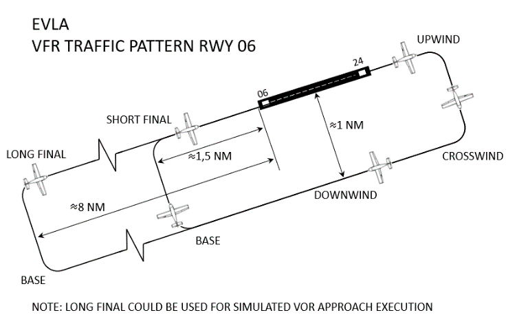
11.4.2 VFR training flights shall be conducted in compliance with the published VFR aerodrome standard or extended traffic circuits (see figure1 and 2) and Visual Approach Chart EVLA AD 2.24.14.
Figure 1
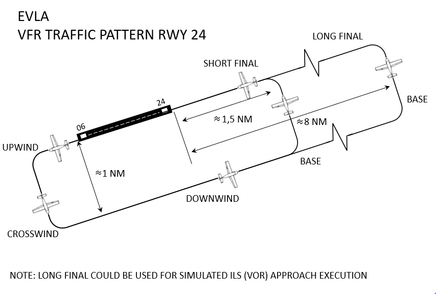
Figure 2
11.4.3 No more than 3 VFR Category A and B Speed Approach aircraft, following the standard VFR training procedure may conduct the training flights simultaneously in the VFR traffic pattern. Additional VFR flights (training and other) are allowed to depart and leave TIZ/TIA zones, as well as to enter TIZ/TIA to land at aerodrome.
11.4.4 VFR training flights or simulated instrument approach shall not be executed:
a) when the ceiling is less than 1 500 ft.; or
b) when the ground visibility is less than 5 km.
11.4.5 Simulated instrument approach under VFR condition shall be conducted in compliance with the published VFR aerodrome standard or extended traffic circuits (see figure1and 2).
11.4.6 ILS for RWY 24 for simulated instrument approaches is available (see EVLA AD 2.19 Radio Navigation and Landing Aids)
11.4.7 A pilot conducting a VFR training flight or a VFR training flight with simulated instrument approach shall report:
- intentions regarding training flight manoeuvres;
- joining downwind (standard or extended downwind);
- short final (long final);
- other reports, by AFIS officer or another pilot request.
11.4.8 When necessary, for maintaining of safe distances between the aircraft, the pilot of VFR traffic shall proceed to VFR holding patterns (see EVLA AD 2.24.14) at 1000 ft, leave TIZ or land the aircraft and hold on the apron on the parking stand.
11.4.9 IFR traffic, departing from or arriving at Liepaja aerodrome, has a priority over the aircraft conducting a VFR training flight, the pilot of which has to either proceed to VFR holding pattern (see EVLA AD 2.24.14), leave the TIZ/TIA or to land and wait on the apron on the parking stand.
11.5 IFR training flights
11.5.1 IFR training flights are conducted in accordance with Instrument Approach Charts
11.5.2 Only one IFR training flight may be conducted at any one time.
11.5.3 IFR traffic departing from or arriving at AD Liepaja has priority over IFR training flights, the pilot of which has to leave the TIA/TIZ or land and wait on the apron, on the parking stand.
11.5.4 An IFR training flight has priority over aircraft conducting a VFR training flight, the pilot of which has to either proceed to the VFR holding pattern (see EVLA AD 2.24.14), leave the TIA/TIZ or land and wait on the apron, on the parking stand.
11.5.5 Simultaneous IFR and VFR training flights shall not be exercised.
EVLA AD 2.23 ADDITIONAL INFORMATION
1. Cases of Equivalent Level of Safety (ELOS) and deviation description
|
Applicable requirements |
Deviation description |
|---|---|
|
CS ADR-DSN.B.045 Width of runways (a) |
Liepaja aerodrome RWY width is 40 m - required 45 m. |
|
CS ADR-DSN.B.185 Transverse slopes on runway strips (a) 1) |
Transverse slopes in some compartments of a RWY strip exceed 2,5%. |
|
CS ADR-DSN.D.245 Width of taxiways |
Taxiway width is 18m. |
|
CS ADR-DSN.D.335 Holding bays, runway-holding positions, intermediate holding positions, and road-holding positions (c) |
An intermediate holding position is not established on the intersection of apron taxiway B and aircraft stand taxilane. Aircraft shall leave the parking only after obtaining the permission for movement from the aerodrome personnel and after receiving "all clear" signal. |
|
CS ADR-DSN.J.480 Precision approach runways (f) |
RWY 24 approach surface is penetrated by an existing objects - trees. RWY 24 CAT I minimum RVR 800m. |
|
CS ADR-DSN.J.485 Runways meant for take-off (e) |
RWY 06 take-off climb surface is penetrated by an existing objects - trees. RWY 06 take-off minimum RVR 800m. |
|
CS ADR-DSN.L.590 Aircraft stand marking (b) |
Aircraft stands does not have a stop line marking. Aircraft should follow the marshalling signal. |
|
CS ADR-DSN.M.630 Precision approach Category I lighting system (b) |
RWY 24 CAT I approach lights length is 450 m. RWY 24 CAT I minimum RVR 800m. |
|
CS ADR-DSN.M.645 Precision approach path indicator and Abbreviated precision approach path indicator (PAPI and APAPI) |
For RWY 24 and RWY 06 the internal PAPI light distance from RWY edge is 18m or 38m from RWY centre line. |
|
CS ADR-DSN.T.905 Fire stations |
During flights aerodrome rescue and fire fighting vehicles on duty are located on the edge of the apron. |
2. RWY 24 take-off minimum RVR 550m.
EVLA AD 2.24 CHARTS RELATED TO THE AERODROME
|
1. Aerodrome chart — ICAO
|
|
2. Aircraft Parking/Docking Chart — ICAO - NIL
|
|
3. Aerodrome Ground Movement Chart — ICAO
|
|
4. Aerodrome Obstacle Chart — ICAO Type A (for each runway)
|
|
5. Aerodrome Obstacle Chart — ICAO Type B - NIL
|
|
6. Aerodrome Terrain and Obstacle Chart — ICAO (Electronic)
|
|
7. Precision Approach Terrain Chart — ICAO - NIL
|
|
8. Area Chart — ICAO (departure and transit routes) - NIL
|
|
9. Standard Departure Chart — Instrument (SID) — ICAO
|
|
10. Area Chart — ICAO (arrival and transit routes) - NIL
|
|
11. Standard Arrival Chart — Instrument (STAR) — ICAO - NIL
|
|
12. ATC Surveillance Minimum Altitude Chart — ICAO - NIL
|
|
13. Instrument Approach Chart — ICAO
|
|
14. Visual Approach Chart — ICAO
|
|
15. Bird concentrations in the vicinity of the aerodrome - NIL
|
|
16. Instrument Approach Chart for Training Flights — non-ICAO - NIL
|
|
17. Arrival and Departure Route Chart — non-ICAO - NIL
|

